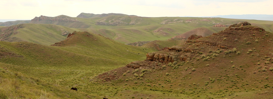
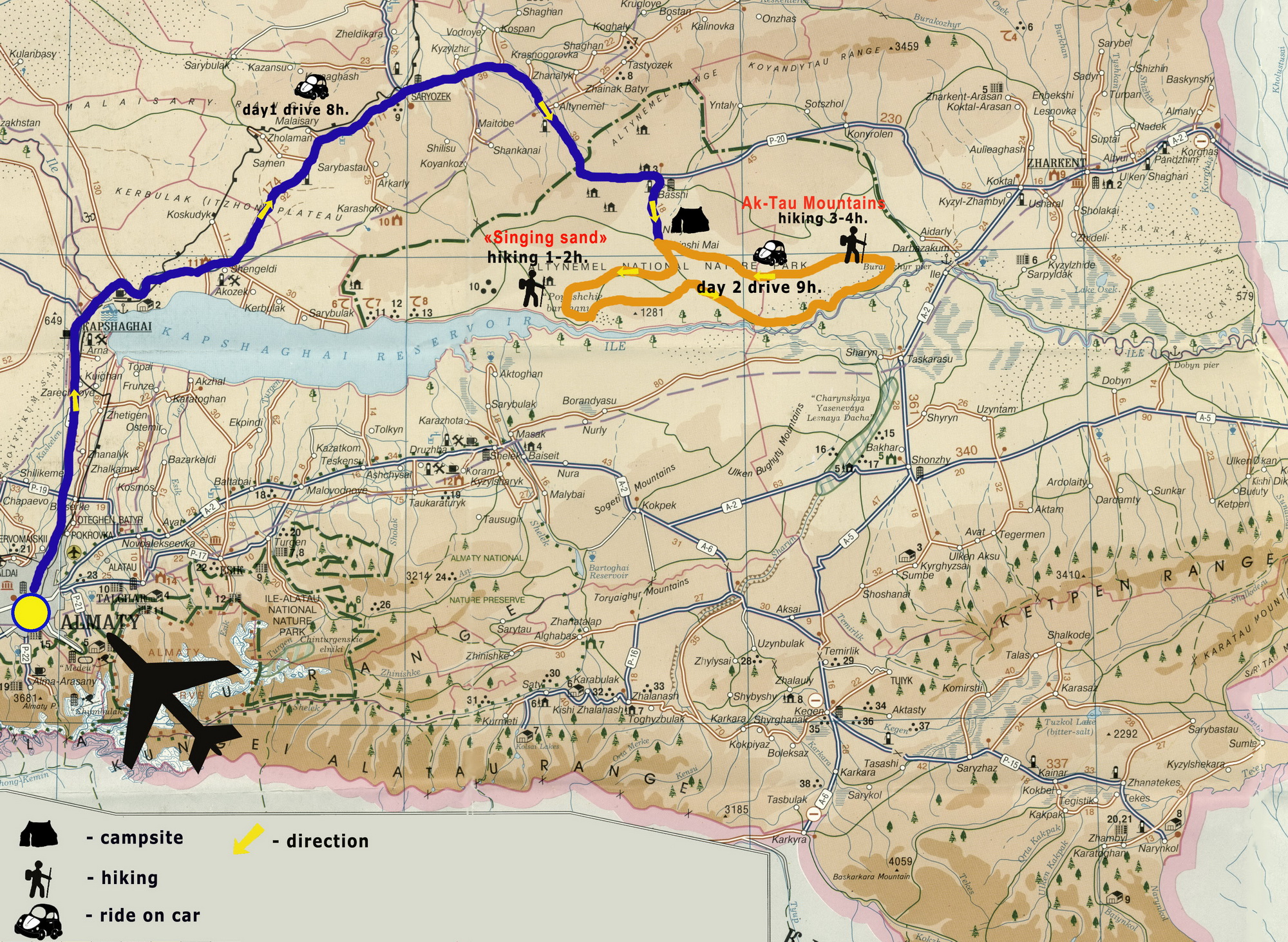
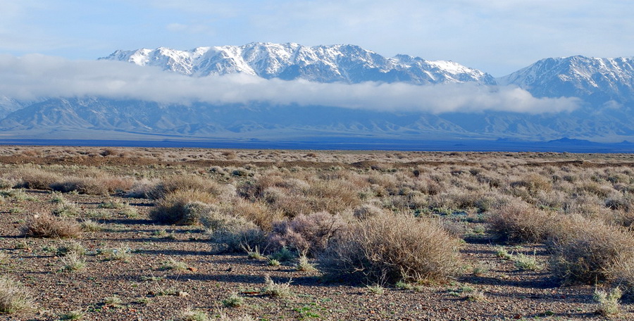
This 3-day trip is primarily about the semi-deserts landscapes of the Semirechye. We pass from the Zailiysky Alatau ridge to the foot of the Dzhungar Alatau Mountains, and we see the "Kazakh Las Vegas" city also, where the casino is allowed. And the military unit, where in 1980 the legendary "Kapchagay battalion" was created. We pass the Kapshagay storage reservoir, the last big project of Kazakh SSR. The small town of Saryozek, where the base of nuclear strategic missiles was placed before the collapse of the Soviet Union. And we cross the pass Altyn-Emel at an altitude of 1711 meters above sea level already in the Dzungarian Alatau.
After go down to the desert zone of the Ili River Basin, we climb to the 150 meter Singing Sand Dune. We take a walk deep into the geological open-air museum the colorful mountains of Aktau, probably in one of the most beautiful and unusual natural parks in Kazakhstan.
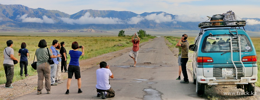
Tour photos 1st day
Click to enlarge the map
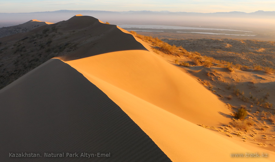
Singing Sand Dune
2nd day. Aktau mountains
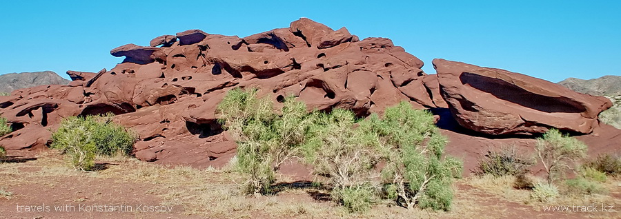
Katutau mountains
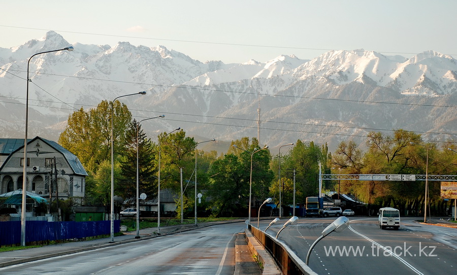
Almaty
Tour Program
1st day
We leave Almaty in the early morning at 7.00 am and continue the way to the east along the Zailiysky Alatau ridge. The ridge and its highest peak Talgar (4975 meters above sea level) are clearly visible from the car window. A flat steppe is from the north to the horizon and in 50 kilometers you can see the sand of the semi-desert approaching to the road.
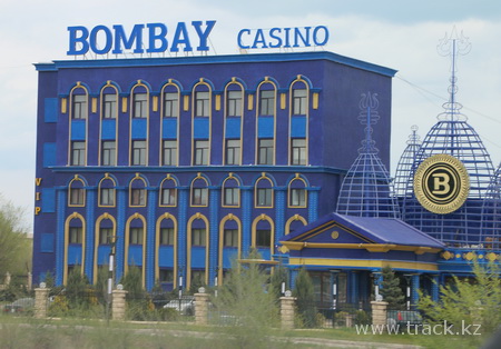
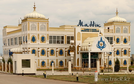
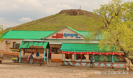
In half an hour we arrive to Kapshagay (the so-called Kazakh Las Vegas) with several dozen pompous palaces on the central street of this small industrial town. It's one of two cities in Kazakhstan, where casinos are allowed.
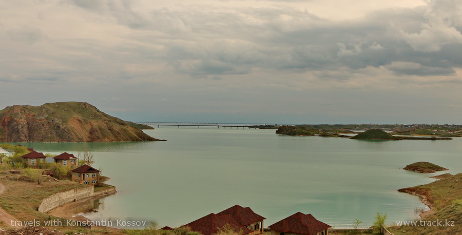
Outside the city you can see the Kapshagay reservoir, which was built in the 80's and is 180 km long and 22 km wide, quite suitable for swimming. In the center of the town there is a military unit, where the legendary "Kapchagay battalion" was created under the leadership of the Kara-major.
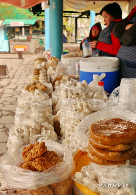
After about 60 km we drive up to the ridge of the Malaysary steppe mountains. The road starts climbing along the serpentine to a small pass of Arkharly (from Kazakh "Arkharic"). Such ridges were rather densely populated by Arkhars mountain sheep 70 years ago. There are roadside cafes before climbing to the pass, but I like more a combination of price and quality in several cafe of Saryozek city.
We cross the Altyn-Emel pass (from Kazakh "golden saddle") just after lunch, and drive up to the Altyn-Emel Natural Park. The road to the park office from Almaty takes about 4 hours. We pay on arrival for a visit to the Natural Park and accommodation at the hotel. They provide us an attendant from the park. This is an obligatory condition, so we have to keep some space and take aboard a local ranger. In the office we spend about 40 minutes for the paperwork, and then we move to the Singing Dune.
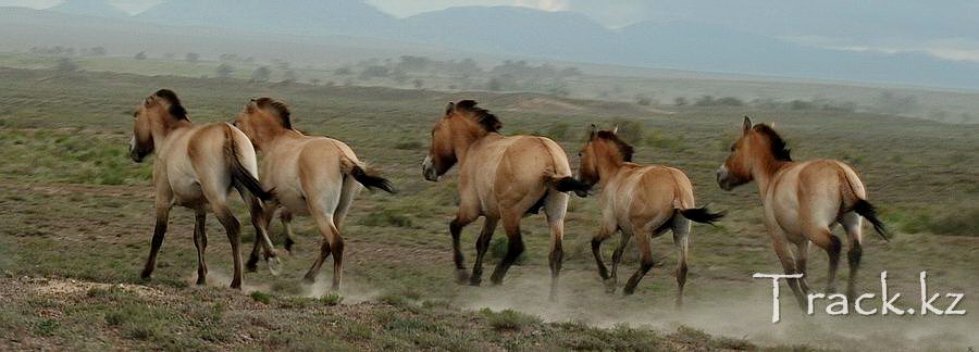
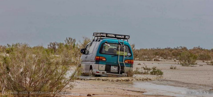
About one hour to drive on a dirt road in the middle of the Kazakhstan Savannah surrounded by a ring of Dzhungar and Tyan-Shan mountains. The road is tolerable, but in some places like a washboard. Along the way, we pass two Jaeger’s cordon, where we show the permissive document for the transit. The road has several forks, as the Jaegers say, not everywhere you can ride, some directions are supplied with thorns from poachers. Exactly on the way to the Singing Dune you can often see kulans and Przewalski's horses.
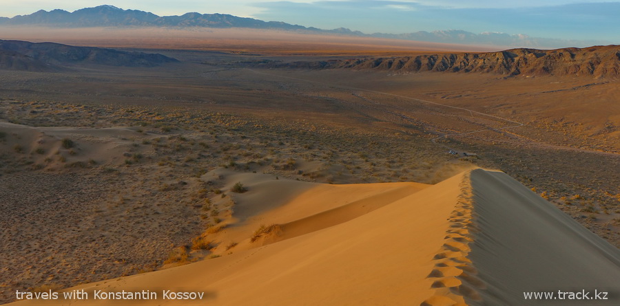
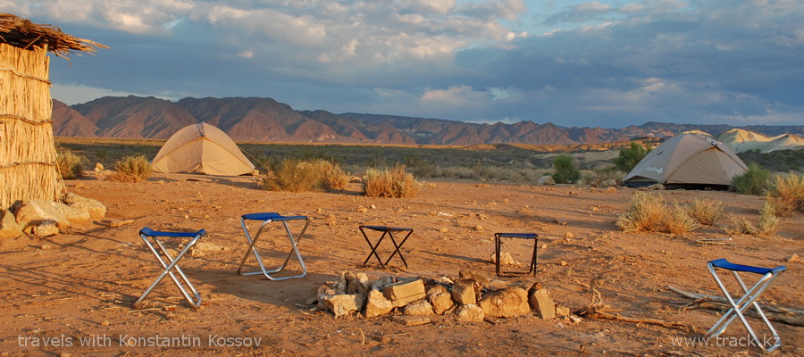
Already at the entrance a yellow ridge of a huge dune becomes visible. On both sides as guardians, there are two stone volcanic origin mountains - the Large and Small Kalkans. Finally, we are near the Sand Dune, going up along the sharp sandy ridge. Legs are stuck in fine yellow sand; to go barefoot is not always possible, sand is too hot. From time to time the wind comes and cruelly lashes with sands on the open parts of the body. Photographic equipment is better to hide in trunks, to be available only in moments of calm. After 40 minutes we rise to the very top of the sandy peak. Above it is visible the wriggling ribbon of the Ili River, about 10 km from the Singing Dune, which in the lane. From Mongolian it means "flickering". Beyond the Ili River the horizon prop up the Zailiysky Alatau ridge from the south. The Dzungarian Alatau mountain system rises from the north-east. Part of the way we slide down on our buttocks. So the shifted sand is buzzing, partially justifying the name of the Singing Dune. We return to the car with pockets full of sand. On the way back we stop by the spring named after Chokan Valikhanov. Here you can relax a bit from the heat in the shade of a turango grove and wash up with slightly salty spring water. Turanga, a fairly rare species of poplar, grows in the semi-deserts of South America and Central Asia. The tree is notable for the fact that during the vegetative period it is capable of evaporating up to 30,000 liters of water.
In the same way we return to the hotel. After a day full of impressions, we will have a well-deserved rest, a shower and a delicious dinner.
2nd day
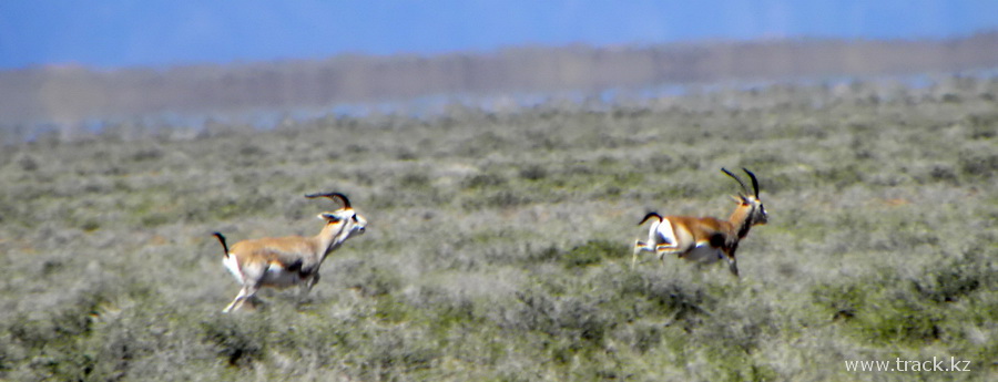
Breakfast. It is advisable to plan the departure in the early morning, if you want to see gazelles. At this time they ply from the mountains to the watering place to the Ili River and back. We drive through several villages, where you can replenish the supply of drinking water. After 70 km we get to the heart of the park multi-colored Aktau mountains, and before that, according to plan, there is one more point of visiting, stone formations in the Katutau mountains. The road runs between the steppe ridge and the Ili River. After a while the short grass is replaced by haloxylon (saxaul). It is a semi-desert plant with very strong wood and roots extending under the ground to 30 meters.
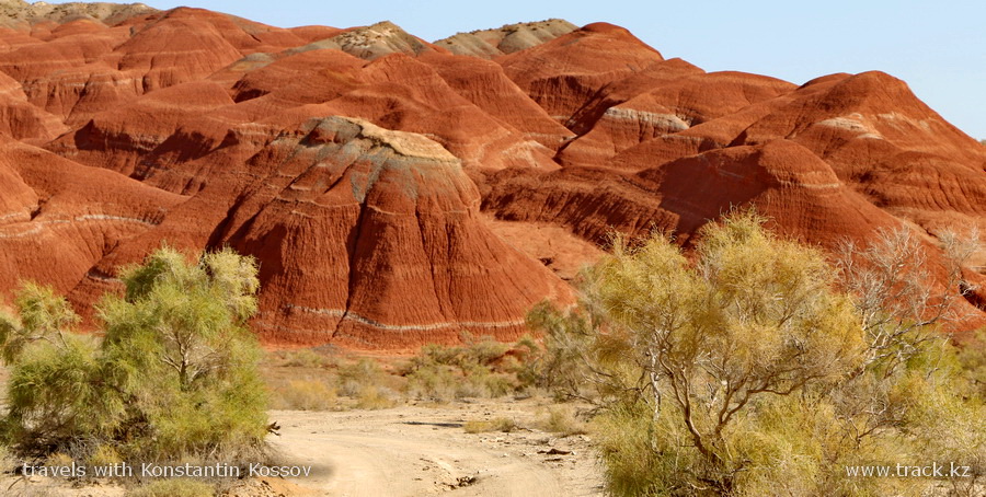
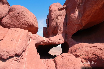
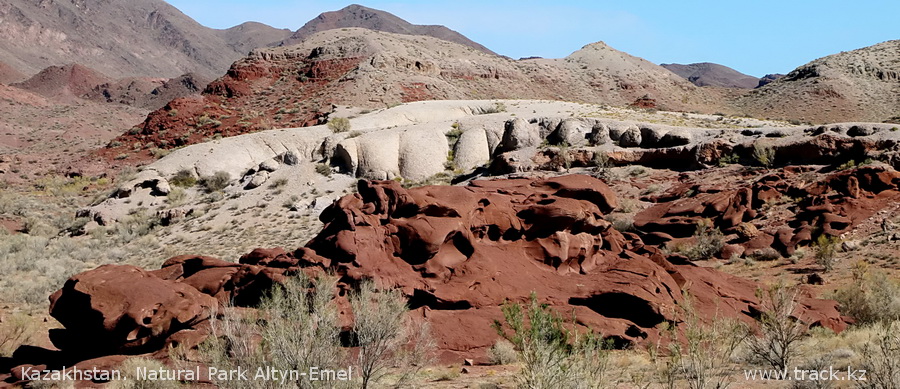
We turn off from the main dirt road to the mountain canyon and after 20 minutes drive up to the most spectacular part of the Katutau mountains. One day the volcano erupted lava on sand dunes, like Singing Sand Dune. Afterwards, the weathering forces have sharpened the stone shell and exposed the porous dark-red sandstone of bizarre rounded shapes, consisting of numerous cavities and bends. We continue to move to the east, so multi-colored mountain ranges begin to appear to our left, a little later an incredibly white massif of the chalk mountains of Aktau shows up on the horizon. When we get closer, we find a desert mountains of red, orange, yellow, brown and over dozen of color spectrum, next to the white massif. After a short break for coffee and rest, we will continue our journey on foot deep into the gorges of these multi-colored mountains. We stock with water, cover ourselves with sunscreen, and begin climbing the corridors-gorges of stone and gypsum. There are another species behind every curve of the gorge. As we move forward, the colors and textures of the mountains around us constantly change. Columns, towers, castles, grottoes. Like if the art director's imagination for a movie about other planets was applied.
The rocks of the surrounding mountains are also heterogeneous: at one moment the whole labyrinths of soft sedimentary clay and limestone, then twenty-meter-high walls of basalt and granite. Wide stone gorges and corridors are with a shoulder width.
A completely different picture, if you climb one of the crest pathways. The breaks of the gorges and corridors are visible from above, along which we walked when we were down; variegated towers and columns, striped hemispheres of peaks.
From above, we see how the multicolored bends of the desert mountains pass into an endless valley, which as far as your eye can see, stretches to the south and ends on the horizon with a wall of the Northern Tien Shan. On the other side there are Dzungar mountains peaks covered with snow.
On the ridges of desert mountains crystals of gypsum sparkle in the sun, stitching the slopes single chains, then gathering in mosaics of meter panels.
There is still a surprise right before the descent. After another bend of the crest a place with the rocks of red and white soil opens.
The impression from the beauty of colorful Aktau mountains you can, and even I'm sure that must be increased, if to wait for the sunset. So an explosion of colors, like a brain explosion, are ensured. Of course, you need for this to spend the night at the foot of desert mountains in tents under the starry desert sky. But as they say, beauty requires sacrifice.
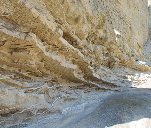
The deserted channels of Aktau mountains are safe in dry weather, but in the spring rainy season they could become mudflowing. Water gathers in valleys located above and rushes through the mountains. In bad weather, it is worth remembering this and avoiding going down into the riverbeds, let alone setting up tents.
Travel time - 3 hours
Walk - 2-5 hours
Total tour time - about 10 hours
Asphalt - 0 km
Dirt road - 170 km
Overnight at the hotel or in tent
3d day
Breakfast. We return to Almaty or continue our journey through the Altyn-Emel Park with a view of visiting the Besshatyr burial grounds. For this we return the same road about 140 km to the Shengeldy village, where we turn off the road and through the village we go first in the direction of the reservoir and then turn east and drive along it. We arrive at post number one to take aboard the Jaeger, and for about forty minutes to move along the dirt road between the steppe mountains of Zhelgashir and the Ili River.
The burial ground of Besshatyr stretches from north to south for 2 km, from east to west for 1 km, and consists of 31 mounds.
Guidebooks also indicate petroglyphs in one of the mountain canyons nearby, but it's still an hour of driving (there-back) on a bad road and sharp rocks, which in my opinion is not worth it. A dozen of fairly common petroglyphs of goats, sheep. The same road we return to main road and go back to Almaty.
Recommendations for the tour
How long does it take for the tour?
We need three days for the Altyn-Emel Natural Park, when we spend 30 hours for three days tour. Of these, 15 hours of only driving. And here the burial grounds of Besshatyr and the visit to the Valikhanov museum are not included yet. Below there is a short overview for the doubters.
1 day. The way from Almaty - Baschi - 4h. Registration of passes - 0,5 hours. Lunch is 1h. Moving to the Singing Sand Dune - 1h. Walk on the Dune - 1,5 hours. Transfer to the hotel - 1h. Dinner - 1 hour. Stop for photos and so on - 1h. Total on the first day - 11h.
2nd day. Breakfast - 1 hour. Transfer to the mountains of Katutau - 1,5 hours. Walking along the Katutau - 0,30h. Transfer to the Aktau mountains - 1,30h. Lunch is 1h. Walking through the mountains of Aktau 3-5 hours. Rest - 1 hour. Moving to the oasis - a 700 year old willow - 1h. Transfer to the hotel - 1h. Dinner - 1 hour. Stop for photos and so on - 1h. Total on the second day - 13h.
3d day. Breakfast - 1 hour. Transfer to Almaty - 4h. Lunch on the way - 1h. Total 5 hours. Of these, 480 km of asphalt and 235 km off-road.
What you need to do before the tour. Before leaving to the Altyn-Emel park, book a place in one of the hotels in advance, and you can also pay permission to travel to the park. This can be done at the office in Almaty, Bogenbai batyr street 132, office 305a. corner Panfilov Street. Phone: 8 (727) 296-40-92.
You can try to do this on the spot in the office in the village of Baschi, but in this case there is a risk that the necessary places are occupied.
Also, if you are going to visit the burial grounds of Besshatyr, you need to pay all fees to the park in Almaty and agree about arrival time of accompanying to meet you, since the turn to the burial grounds of Besshatyr is in the Shingildy village, which is 140 km closer to Almaty than the Basshi village.
Or do it on the way back.
Season: April - November. In principle, the Altyn-Emel Natural Park is open all year round, but snow drifts can prevent snow trips during winter.
What to take with you. In the summer in Altyn-Emel it will be hot, so take not heavy and light colors clothes, preferably covering the entire body.
Do not forget the hat, sunglasses, sandals, sneakers or boots to walk deep into Aktau mountains. Also need for repellent from blood-sucking mosquitoes and ticks.
In early spring and late autumn, we add a jacket and a warm underwear, for the cold evenings and cheerfully blowing wind.
How to get there. At the moment, I can recommend only trip with reliable guide on a car prepared for such journey. For independent travel, either rent a car, or get to the Basshi village by taxi going to Zharkent.
Usually such cars depart from the Sayran bus station of Almaty. And further negotiate in the park about local transport which take you to the Singing Dune, the Aktau mountains and other points of interest on the route. It is necessary to agree on such options in advance in Almaty in their office.
If you go by your car.It is preferable that it would be an SUV or a crossover on "mud-stone rubber". Sharp stones with ease punch the track rubber. Therefore, need for spare wheel, pump and a set of "shoelaces" for tire repair.
On the Singing Dune you can still drive the normal car. In the multi-colored mountains of Aktau is already more complicated, a lot of flood erosion, through which it is necessary to carry the sedan. And if it rains, forget about the underdrive, the clay of dirt roads soaked with water will take you into its arms.
Where to sleep. The newest Aigakum Hotel is across the street from the office. It's a comfortable place to stay overnight. There are 2 local standards with a shower and toilet in the corridor - 10000tg. Junior suites 2-bed rooms with shower and toilet inside - 12000tg. Two 2-bed suites-14000t. Cozy dining room. The food is delicious. For the season of 2016, I would recommend it. The price for 2016 is 5000-tg per person plus around 3,500tg per day for food.
Altyn-Emel Hotel is located next to the office, through the courtyard. Here is pretty normal rooms. Shower rooms and toilets on the same floor. Previously, the food here was weak, for my taste. The last year has ceased to be placed there, there is no fresh data. The price for 2016 is 5000tg per person plus around 3500 per day for food.
Shygan Hotel is located a few km from the Baschi village. Conditions are the most modest of all three. Shower and toilet are public. For not picky tourist it will be fine. No food. Well, if only arrange and you will cook from the products you brought. The price for 2016 is 2500 tg. per person.
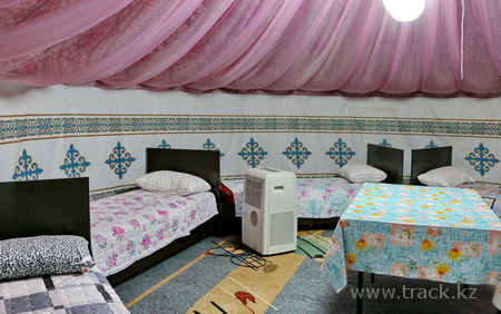
Guest yurts located next to the Aigaikum hotel, 5-6 people capacity. Bunks and bed linen are present. The cost is 3000tg per person. Meals as well as in Aygaikum, can be ordered in a yurt. There is a toilet and a shower outside.
Shelter on the map Mynbulak with spartan conditions. Room and bed. The toilet is outside. 1000tg per person.
When spending the night in tents in the park, stock up on repellent from mosquitoes, sometimes they are bloodthirsty.
Where to eat
The gas station of Gazprommeft has a fresh coffee, around at 8th km. Cafes in the city of Kapshagai is 56 km from Almaty. Arkharly pass is 120 km. The town of Saryozek is 156 km away. Aigaykum Hotel - 241 km, it is better to call to order food in advance.
Of all the listed for me in 2016, I liked food in Kapshagai and in the Aigaikum hotel, just because we arrive to Aigaikum to dinner time.
Conveniences (WC)
Toilets with water closet on the road from Almaty; Approximately 8 km - Gazpromneft gas station, 120 km - before the pass of Arkharly. Along the entire Kapshagay route to Saryozek there are street toilets (for sure it smells, but better than nothing). For Saryozek toilet is in the open field.
0 km - the beginning of the route, the northern border of Almaty, from this place and to the city of Saryozek, 6-lane concrete road.
56 km from Kapshagai
67 km - turn to Bakanas, to the left, and we go straight
95 km - the Shengeldy village, if you are going to drive to the burial grounds, you need to turn right, drive through the Shengeldy and along the shore of the Kapshagay reservoir to cordon No. 1 Taigak.
105 km - beginning of the ascent to the Arkharly pass
120 km - beginning of Arkharly pass
156 km - fork in the city of Saryozek, before the fork, the last decent refueling
217 km - Altyn-Emel Pass
239 km - signpost to the Basshi village, so here turn right, not reaching 300m. gas station index
241 km - signpole of GNPP "Altyn-Emel", turn left, drive up to the street with a dividing strip of green spaces, turn right and go to the first turn to the left, turn left and we are in front of the office of the park Altyn-Emel
286 km - Singing Sand Dune
311 km - Aktau mountains
To compose the legend of the route was used information from the site; https://kolesa.kz/content/articles/2012/04/marshrut-n13-2012/
Precautions - we should remember that the corridors of the desert mountains of Aktau are filled with mudflows in rainy weather. In this case, above the place where you walk the rain may not be, but storm clouds over adjacent foothills should alert you. In such weather for the walk around Aktau you need to choose the ridges. Tents should be placed outside the dry channels.
Theoretically, such insects as Karakurt, scorpion, tarantula, and greyhound can bite you. There are a couple of species of poisonous snakes. In fact, over the past 10 years, that he visited the park, and this is more than 150 days (and nights), and about anything similar did not hear.
Is that one of the rangers in the spring of 2016, was bitten by scorpion, followed by a slight malaise. Usually, the greatest harm is from mosquitoes and alcohol.
So check your shoes before you put them on, look under your feet, be vigilant in the wild and everything will be wonderful.
A mudflow goes on a dry channel
Options to continue the journey
It will be sad if, due to lack of information, interesting places remain without your attention. Therefore, please check which tours you can do for the time you have.
Click the link to check the options for further journey from Altyn-Emel.
From the Altyn-Emel Natural Park you can go to ...
Option 1. 3 days. Altyn-Emel – Tamgaly-Tas
Option 2. 4 days. Altyn-Emel – Charyn National Park
Option 3. 5 days. Altyn-Emel – Charyn National Park – Assy Plateau
Option 4. 5 days. Altyn-Emel – Kolsay lakes
Option 5. 6 days. Altyn-Emel – Temerlik – Tuyuk – Tekes – Tuzkol lake – Almaty.
Tour library
Tour information guide, nature, history, etc.
Kapshagay
In Kapshagay there is a military unit, where in the autumn of 1980 the legendary Kapchagay battalion, the 177th special forces detachment , was formed. Which under the command of Major Kerimbaev demonstrated example of valor and professionalism in the war in Afghanistan.
Link to this story http://friends.kz/newss/1148217817-kara-mayor.html or to the story of the Kara-major himself http://desantura.ru/articles/37/
In 2007, the law "About gambling business" was adopted according to which casinos and slot machines hall are to be located only on the coast of the Kapshagay reservoir and in the Shchuchin district of the Akmola region. The city is the largest gambling zone in the republic.
Where at the moment about 40 casinos are built. Here come people from all cities of Kazakhstan. Sometimes for fun this city is called Kaz-Vegas.
The city grew up due to the beginning construction of a hydroelectric power station. At the place of the reservoir, the Ili settlement was originally located.
After flooding, the residents were resettled in the newly formed fishing collective farm, now called Arna. Now the population of the city is 60 100 people. The reservoir began to fill in the fall of 1969. The Kapshagay HPS was launched at full capacity in 1970.
Kapshagay Reservoir
Kapshagay Reservoir is one of the largest in Kazakhstan, its length is 100 km, width is 25 km and depth is 42 m. It was formed in 1970, by closing the Ili River in the narrow Kapshagay Gorge.
In summer Kapshagay is very hot, the air temperature sometimes reaches +40 degrees. The water temperature in May-June is +18, +20 degrees, July-August +22, +28 degrees.
Today it's the most visited place in Almaty region on summer holidays, where you can swim and sunbathe on the beach.
The most developed on Kapshagay is its northern shore, where there are numerous recreation areas and boarding houses.
Most of Kapshagay's rest houses are part of a single coastal complex, which is commonly called the urban recreation area. Almost all recreation areas in Kapshagay district have a network of services (boats, motorboats, jet skis, yachts).
At the reservoir, fish breeding was conducted on an industrial scale: bream, pike-perch, carp, crucian carp, asp, catfish, white cupid, various types of crayfish and even shrimps. Of these, only 5 species are endemic. There are cases when they caught catfish weighing more than 100kg.
On the shores of the Kapshagay reservoir some young shrubs are visible here and there. It has been about 30 years since the Kapshagay reservoir was filled, but the coast line from the trees was not formed, this is hampered by fluctuations in the water level that it came, filling the vegetation that has begun to take root, and it decreased, exposing it and condemning it to drying out.
The Ili River
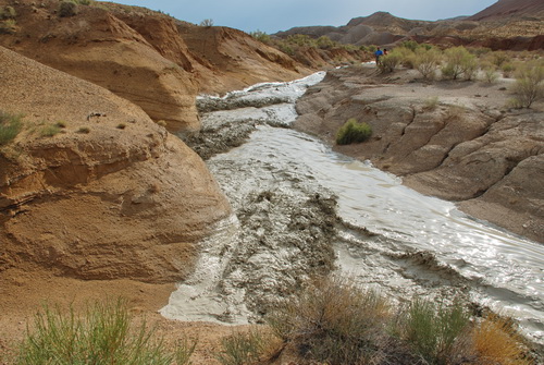
The Ili River flows along a wide valley lying between the two main mountain ranges of the Semirechye, Dzhungar and Zailiysky Alatau. The Ili River in Mongolian means glimmering. It originates in the Tien Shan in the PRC at an altitude of 3540 m. The source of the river is at the confluence of the Kunges and Tekes rivers.
Its length is 1439 km, 815 km (56.6%) of which are on the territory of Almaty region of Kazakhstan, where it is the largest river of the region and one of the largest rivers of the country. It flows into the western part of Lake Balkhash, greatly desalting it.
At the confluence forms an extensive delta with several permanent sleeves: Zhidely, Topar, many small lakes and backwaters. On the right side of the modern river lie numerous ancient channels Ili, the largest of which is Zhanatas.
It is located in the desert. In the delta is the settlement of Kuygan. The Ili delta (like Lake Balkhash) is on the plain. Earlier in the floodplain of the Ili River Turgan tigers were living. But at the moment this species is considered extinct.
The last tiger in the delta of the river, according to reliable data, was killed in 1947 by hunter S. Myakishev. In addition, there is information that needs to be checked that another tiger was killed on the Kazakh-Darya channel in 1950 or 1951. At the end of the 1940s, tigers in the delta disappeared.
At twenty kilometers from the Kapshagay dam on the right bank you can meet a high brown rocks of Tamgaly Tas, on which ancient artists left many of their drawings. The stones depict animals that once lived in these places, scenes of hunting for wild animals.
One of the most interesting drawings is the image of a sitting Buddha, it is executed, apparently, in the era of Sogdians, with whom the spread in the Semirechie of Buddhism is associated.
Below, along the course of the Ili River, there are tugai jungas. The trees here are intertwined with lianas clematis so thickly that in some places it is impossible to go ashore. But the forest is replaced by vast green meadows, and sometimes the desert approaches the shore itself.
On the banks of the Ili River, you can meet bushes juzguna, white saxaul, turanga groves.
In the Ili River there are many fish, and any tourist will easily catch a bream, carp or asp. In the steppe, you can look for mushrooms - champignons and white steppe mushrooms are quite common here. In the tugai, near the Ili River, a blackberry grows.
Traveling along the Ili River, especially near the village of Bakanas and below, is complicated by the fact that there are a lot of various channels and sleeves, shoals and ruts, there are snags - trees and shrubs, hidden by a layer of water. There is quite a lot of whirlpools and funnels on the river.
Баканас(в букв. пер. с каз. «сухое русло») — древняя дельта реки Или. Старая дельта начиналась в прошлом севернее Bakanas (in the literal translation from kazakh "dry river bed") is the ancient delta of the Ili River. The old delta began in the past to the north of the regional center of Bakanas, 340 km from the modern mouth and occupied up to half of the territory of the Saryesik-Atyrau and Bestas deserts. At the same time, the Shet-Bakanas sleeve ran into the eastern part of Lake Balkhash.
Other large dry beds - Ortabakanas, Narynbakanas and once the largest Zhanatas, created a fertile irrigated drift cone in the desert area, which became the center of a medieval agricultural civilization. An important role was played by hunting in tugai forests and fishing in the waters of the Ili River and Lake Balkhash.
In the ancient delta in the IX-XIII centuries there were several cities located one from another at a distance of 40-45 km. The northernmost and one of the largest ancient cities of the Great Silk Road on the old river bed of the Ili River was Karamergen (literally "Black hunter").
Irrigated agriculture in the delta declined after the invasion of the Mongols. Over time, due to the intensive alluvial activity of the river, its old northern delta became too high and the river's waters, under the influence of gravity, rushed to a lower terrain to the east. It is possible that seismic shifts also played a role in this process.
History of shipping on the Ili River.
For the first time the ship was launched here in the summer of 1854. St. Nicholas sailing vessel was built, on which the merchant Kuznetsov undertook the supply of provisions for the Kazakhs living in Verny city. The path on a sailing ship from Lake Balkhash to the village of Ilisk took 72 days. And back to the mouth of the Ili River - 17 days.
In 1883, the engineer Kozollo-Pokljevsky Y.Y. made an attempt to build a steamship post on the Ili River. He ordered a small helical steamer in England, with 35 horsepower capacity, called Kolpakovsky, in honor of the governor-general of the city of Verny. On March 14, 1883, the ship was launched on the Ili River. This steamer delivered 800 poods of wheat to the headwaters of the river.
In the 20th century, the study of the Ili River resumed. In 1812, engineer Abdulin worked here. He concluded that for successful shipping, significant costs are required, for piercing the fairway in the areas of shallowing, constant work of the dredgers is necessary, considerable sums will be spent on maintenance of the buoy-breeders who follow the change in the fairway and designate it with buoys.
In 1926, an expedition of Soviet specialists worked on the Ili River. The researchers noted the difficulty of navigation, which consisted in the variability of the fairway, the abundance of chalk, the rapidity of the flow of strong winds and the desolation of the coast.
Time of rapid development of navigation came in the 30 years of our century. In 1929 a sailing-and-breeding vessel Balkhash with a displacement of 33 tons was launched. And in 1934 the waters of the Ili River were already sailed by sixty self-propelled vessels, tugboats and barges.
Arkharly pass - a place where you can stop for a snack and use the toilets.
Saryozek.
Here is severe continental climate, in summer +40 in the shade, in winter to minus 50 at night, piercing winds, dusty tornadoes. In translation from the Kazakh "Saryozek" means "yellow sand". No, there was no desert, in the summer withering wormwood, the panicles of a gray feather grass, the balls of a rolling field. But in the early spring the terrain is being unrecognizably transformed. There are many flowers, first snowdrops, then poppies, red and yellow tulips ... Especially a lot of poppies. When they blossomed on the slopes of the mountains, they merged into huge scarlet spots.
During the war in China in the 30s of the last century it was used as a trans-shipment point for deliveries of Soviet military equipment to China.
Also, earlier, there were bases of nuclear missiles, the main targets of which were US military bases in South-East Asia. When relations with China were aggravated, in addition to strategic ones, a team of operational-tactical missiles was deployed. With the collapse of the Soviet Union and especially with the departure of the military base began to decline. After Kazakhstan destroyed its nuclear weapons, becoming the first country to voluntarily abandon it. Now one military town has been restored and occupied, but now there is a military unit of the Novgorod division, the second in the reconstruction stage.
At the moment in the village are located oil storage (oil depot) and the central automobile base. There are also deposits of gold ores that have been mined since 1955 to this day.
Altyn-Emel Pass. It is located at an altitude of 1711 m above sea level in the Dzungarian Alatau between the same mountain range (2938 m) and the Matai ridge (2880 m). The name Altyn-Emel has Mongolian roots and in translation it sounds like a "golden saddle".
The village of Basshi. Coordinates 44 ° 09'32 "s. W. 44 ° 09'32 "s. W. 78 ° 45'07 "in. etc. Tel. code of the city is 8 (72840).
The village is located in the Kerbulak district of the Almaty region in Kazakhstan. According to the 2009 census, there are 1,831 people. In the village there are a couple of shops. There are two hotels and guest yurts.
In the village of Bashshi there is an office of the Altyn-Emel natural park, you can find it by following the road signs. On the first floor of the office there is an exposition devoted to the sights of the park. The central manor of SSPP "Altyn-Emel" is located in the village. Bashshi Bashishsky rural district of Kerbulak district in 280 km. From the city of Almaty, 90 km. From the district center of Saryozek, 120 km. From the city of Zharkent, in 190 km. From the regional center - Taldykorgan.
Altyn-Emel National Natural park.
The park was organized on April 10, 1996. The total area, including the protection zone 523 053. The security zone, 62 845 hectares. The National Park is located in the Ili Basin. According to the natural physicogeographical zoning, it is part of the Ili semi-desert region, the Ili-Balkhash-Alakol desert basin.
The northern border of the Altyn-Emel SNPP runs along the south-western spurs of the Altyn-Emel Ridge. These are mountain ranges (from the south-west to the north-east) Sholak, Degeres, Matai, Altyn-Emel. In the extreme west, the area where Sholak foothills almost reach the floodplain of the Ili River, leaving a narrow entrance to the valley, serves as its western boundary. The eastern border runs along the floodplain of the Kokterek River, which flows into the Ili River. The southern boundary of the park forms part of the coast of the Kapshagay Reservoir and part of the Ili River floodplain with a water area.
The climate in Altyn-Emel is deserted, sharply continental, with dry cold winters and hot summers. The annual amount of precipitation does not exceed 330 mm, the prevailing number is in April-May. The driest month is September. The average temperature in January is -8.6 ° C, the minimum temperature is -29.5 ° C. The average July temperature is + 26 ° C, the maximum temperature is +45 ° C. The period with an average temperature above 0 ° C is about 260 days, and with a temperature above 10 ° C - 186 days.
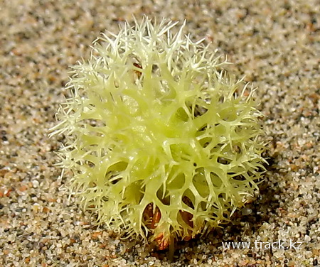
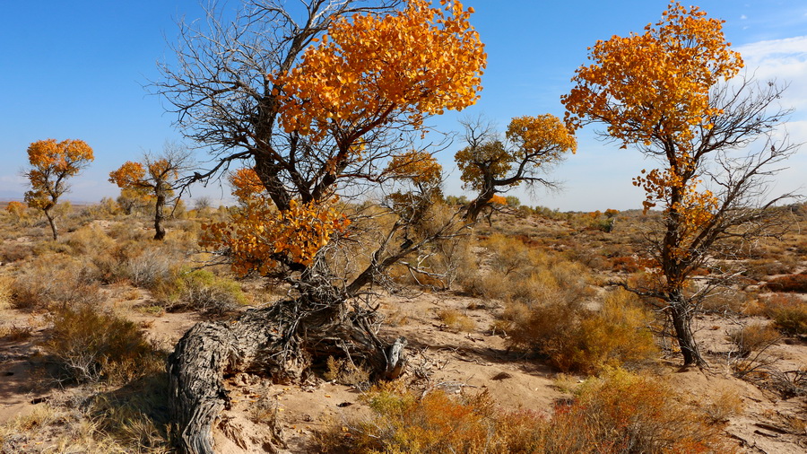
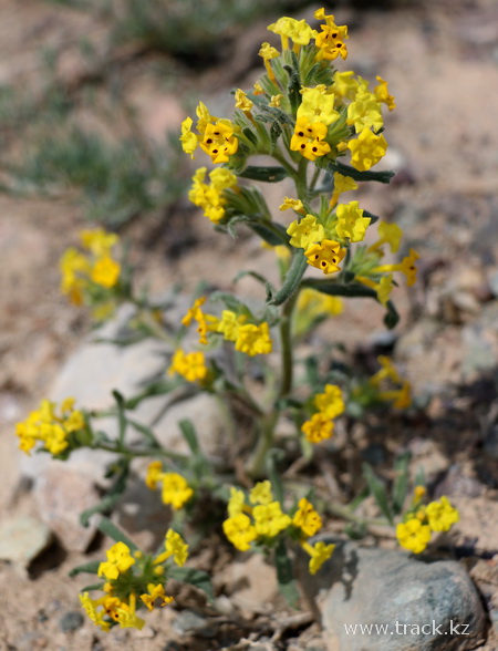
The territory of the park is represented by four vertical belts: deserts are real, deserts are steppe, mountain steppes and high-mountain meadows. The Flora includes 634 species of plants, 41 of them are rare, 29 are endemic, and 22 are listed in the Red Book. In the floodplain forests grow poplar turanga, jida and various types of shrubs.
In the desert there is a very interesting plant - saxaul. The length of the roots, which due to lack of water in deserts and steppes reaches up to 25 meters. A large shrub in height 1,5-2,5 m, and sometimes up to 5 m, growing on the desert sands. The very wood of this plant is very strong.
Coals of this plant for a long time smolder and emit a lot of heat, because of which they are used with pleasure for cooking barbecue. It's perfect, and sometimes even the only food for camels throughout the year.
Camels can eat saxaul bushes up to 3 m in height and can receive from one bush to 12 kg of fodder. For sheep, only dry leaves and twigs (up to 1 kg from one bush) that have fallen to the ground are available. It forms desert-tree thickets - saxaul forests, the area of which in southern Kazakhstan is about 15 million hectares.
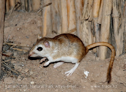
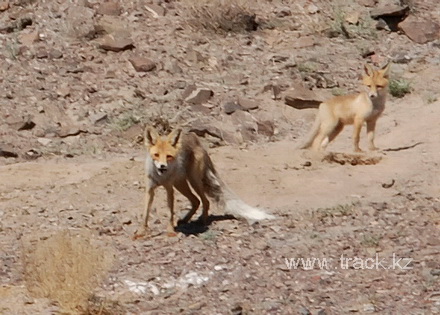
The fauna of mammals includes more than 50 species, among which such rare as snow leopard, wild cat-manul, Central Asian otter, stone marten.
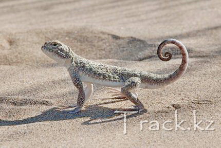
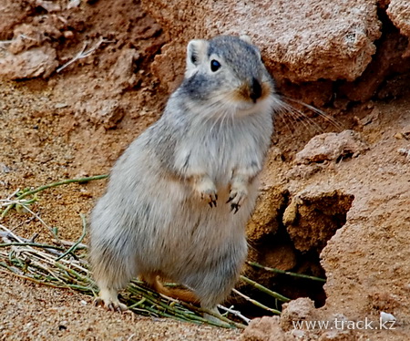
Altyn-Emel is inhabited by large populations of: gazelles (about 4000 individuals), Siberian mountain goat (about 1500 individuals). Also on the territory you can find 4 more artiodactyls: roe deer, wild boar, saiga antelope and argali. And there are two species of ungulates: Kulan and Przewalski's horse.
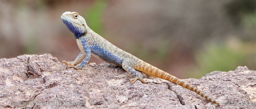
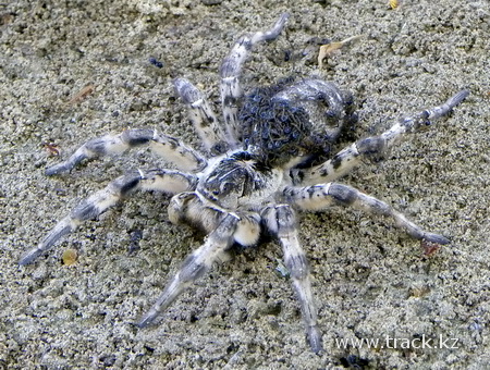
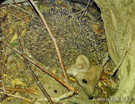
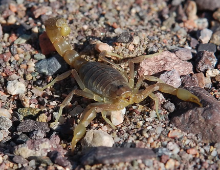
The fauna of insects has more than 5000 species. In the Red Book are listed 25 species. Among the many invertebrates are the oldest of the arachnids - scorpions, common saltpaw and tarantula, karakurt.
The female, more poisonous in the pair of Karakurts, is distinguished from the completely black male by the presence of eight red dots on the upper part of the abdomen.
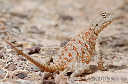
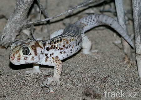
Reptiles are represented by 25 species. In the mountains, the Alayan lidless skink, the shield-muzzle, the steppe adder, the patterned skid are common, and in the desert and the semi-desert - the steppe turtle, takyr and motley roundhead, the scintillation and gray gecko, the steppe agama, several species of foot-and-mouths, arrow-snake and others.
Twenty species of fish live in the Ili River and the Kapshagay Reservoir. Of these, three species are endemics: the Balkhash perch, the Ilya marinka, the one-color sponge. Other species are acclimatized: carp, white amur, silver carp, asp, catfish, bream, pike-perch, Caspian vobla, etc. Four species are included in the Red Book: thorn, Aral barbel, Ili marinka, Balkhash perch.
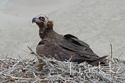
In Altyn-Emel park can be found 250 species of birds, of which 22 are rare. In the mountains nestle golden eagles, snake-eaters, bearded lambs, Falcon - Baloban and others. In the desert there are black-bellied fennels, sajis and beauty-bustards. In the wetlands, herons, ducks, sandpipers and other birds live.
Kulan - Endemic Kazakhstan subspecies of Kulan disappeared in 1937, although at the beginning of the last century it was spread throughout Kazakhstan from the river Ural to the lake Zaisan. In 1982, the Kulans of the Turkmen subspecies were brought to the Sholak Mountains, they got comfortable in the park and now there are more than 400 of them.
Another rare species, Przewalski's horse, disappeared from Kazakhstan in the century before last, and from wildlife in general - in the second half of the last century. By now, wild horses have survived only in several zoos in the world.
In 2003, several horses were brought from Germany to restore the species in the wild. Now they are already familiar with the new conditions.
The history of the formation of the local saiga population is interesting. In the harsh winter of 1976-1977, the herds of saigas, migrating far to the south, came into places unusual for them.
A small group of these animals penetrated the ice of the Kapshagay Reservoir to the foot of the Sholak and Matai mountains, where they remained until the spring. In the spring, when the ice melted, the saigas could not go back and were forced to develop a new territory in the foothill valley.
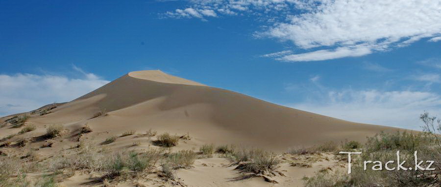
Singing Sand Dune (Barkhan).
Between the Big and Small Kalkan Massifs, the prevailing winds bear a huge sand dune named Singing Dune (barkhan) because of the occasional low hum from it.
The huge barkhans, the length of the crest of which is more than 2 km, and the height is 150 m, is located near the banks of the Ili River. The entire sandy ridge covers an area of about 10 square kilometers.
Unlike other barkhans, the Singing one does not change its outlines and forms, because in the valley between the hills exists a special direction of the wind rose. The edge of the unique barkhan is sharp as a blade. The grains are crumbling underfoot, but the point does not flatten.
The voice of a barkhan can be heard only in dry weather, after a rain the sandy mountain is silent. There are many hypotheses that explain this phenomenon by the friction of moving particles or resonance. However, there is still no exact answer as to why this barkhan is singing.
It is possible that the sounds are the result of the scattering of grains of sand on the slope. There is an explanation: the hum is caused by the electrization of sand. Some scientists believe that sound is born when a lot of sand particles rub against each other. The grains are covered with a thin coating of calcium and magnesium compounds, and the sounds appear like if the violins are held by a bow smeared with rosin. Other researchers believe that the main reason is the movement of air in the gaps between the grains of sand. When the barkhan is showered, the gaps between the grains of sand then increase, then decrease, the air then penetrates them, and then comes out of them. This causes sound vibrations. Due to friction, the sand particles singing mountains are charged with opposite electric charges and start to push off one from the other. And this causes sounds like in the ordinary electric discharge. Soviet scientist Ryzhko Y.V. managed to artificially obtain such sounding sand. He took ordinary river sand, dried it and cleared it of dust, removed all foreign impurities from it and then electrified it with a conventional electroforming machine. And the sand began to sound - with the pressure on him with a hand, he made creaking sounds. Researchers have established: sand sounds only under certain conditions. It is capable of only very pure quartz sand, with grains 0.3-0.5 mm in diameter. And in damp weather or after a rain he is silent.
"On the reasons for the sound of sand," writes Marikovsky P.I., - there are many conjectures. However, they all refer to the gentle squeaking of sand during its movement, but do not explain the rumble. It seems to me that the rumble of sand, a sound very similar to the roar of a jet plane, can be explained by the following. In any barkhan at a shallow depth a layer of compacted moist sand forms. In the spring after the rains, as well as in autumn, it closes with a superficial, also wet layer, and then the barkhan becomes dumb. In summer, in the heat, the sand dries from above, the moist layer that arises from condensation of moisture from the air, lies deeper, but under it dry sand again flows. When a sand avalanche flows along the sand dunes, the upper layers of sand, experiencing less friction, overtake the lower ones, and a peculiar, well-noticeable undulation of the surface arises. It is transmitted by jolting to the layers of moist sand, and it, like the deck of a musical instrument, resonating from the vibration of a string, begins to vibrate, producing a characteristic hum. "
By the way, when such sand is brought for study in the laboratory, it becomes silent. But if it is placed in a hermetically sealed vessel, it again begins to sound.
It is located on the right bank of the Kapshagay Reservoir, at the confluence of the Ili River. This is one of the steppe favorites, on visits to tourists.
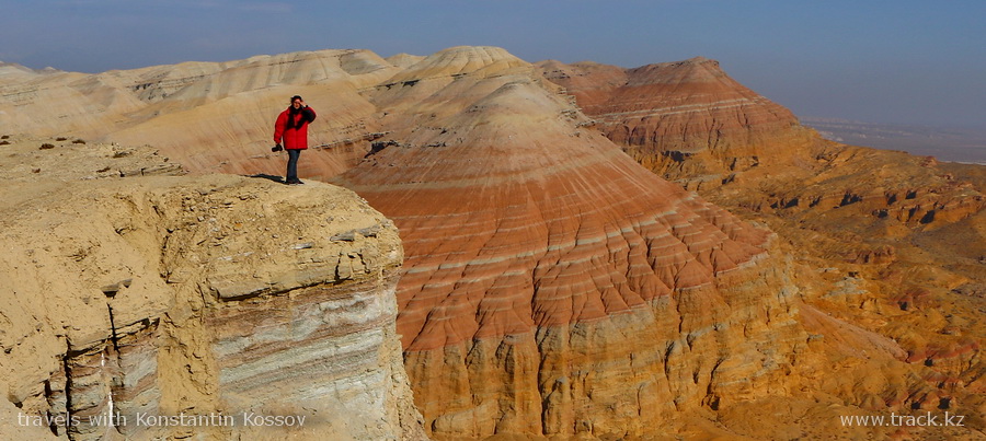
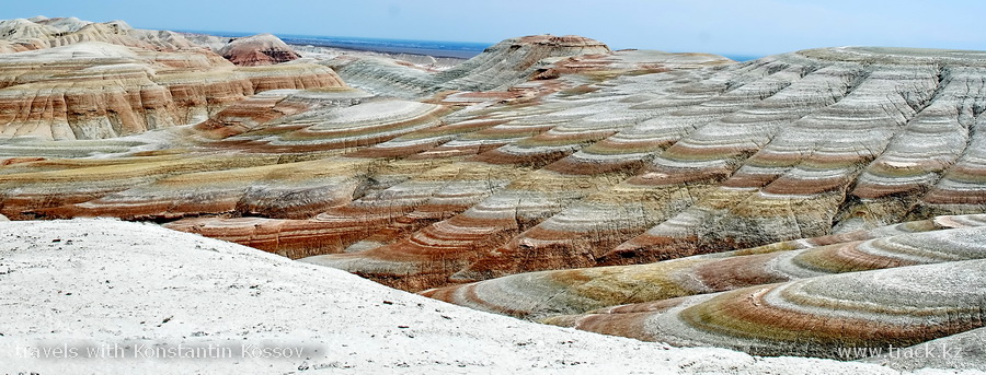
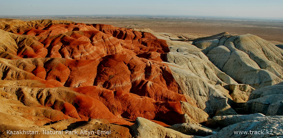
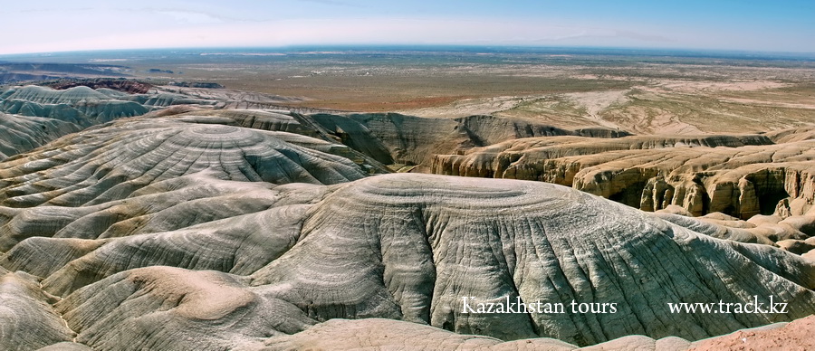
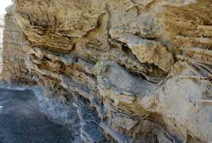
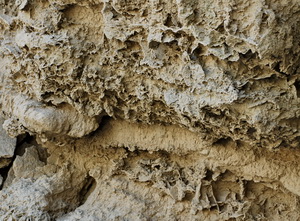
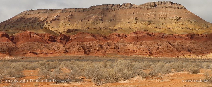
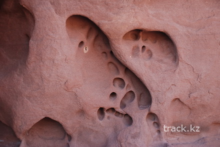
Aktau Mountains
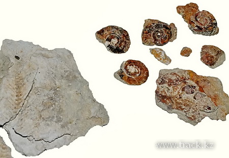
In translation from the Kazakh it means "White Mountains". The chalk Mountains of Aktau are a world famous paleontological deposit. In the layers of Paleogene lacustrine sediments, well-preserved remains of ancient animals are found, whose age is estimated at 25-30 million years. Among the finds are the remains of giant rhinoceroses, crocodiles.
The mountains of Aktau represent a spectacular spectacle of variety of forms, colors and shades: red clays, bluish-gray limestone sandstones, pebble and gypsiferous tertiary deposits. For miles stretch the stone galleries. The texture of the stone changes for each new twist of the meandering gorges. The mountains then go up the Gothic towers and columns, then break into narrow labyrinths, where hardly two men will part.
Great interest in the Altyn-Emel Natural Nark and especially to the mountains of Aktau is shown by scientists from different countries conducting research in the field of climatology, tectonics and paleomagnetics.
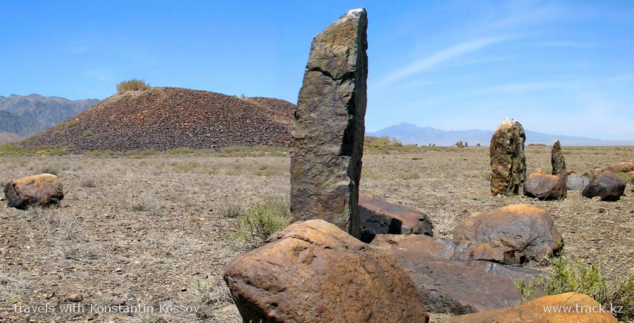
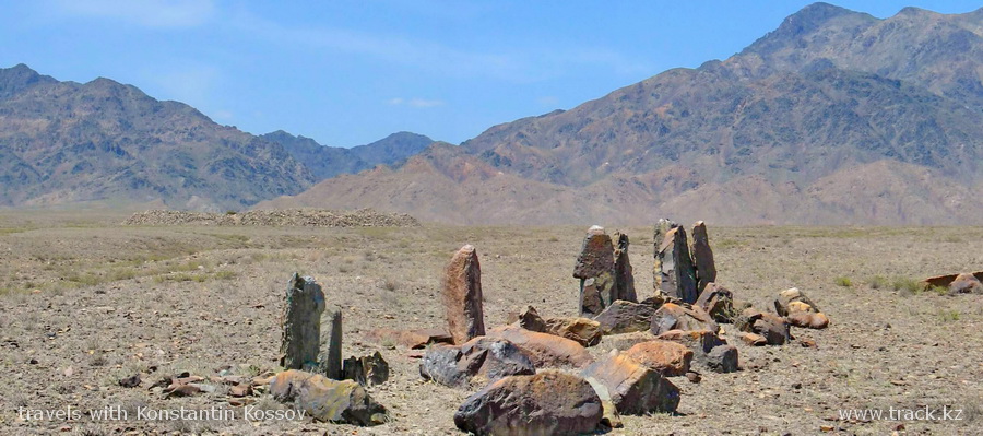
The burial ground of Besshatyr.
The burial ground is located on the right bank of the Ili river at the bottom of the Jelshalgyr mountains, and is 170 km east of Almaty. The burial ground stretches from north to south for 2 km, from east to west - for 1 km and consists of 31 mounds, 21 of which have a stone embankment, the rest - embankments of crushed stone and earth.
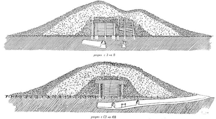
The burial mounds in the burial ground are chaotic, but two groups are distinguished: northern and southern. The largest mound, called Big, is located in the north-eastern part of the burial ground. Its diameter is 104m the average height is 15 m. The mound has the shape of a сonoid with a flat top, 32 m in diameter. The stone mound of the mound at the base is laid in several dense rows, which gives the impression of a socle on which the entire mass of the mound rests. A shaft is built around the mound. Near the embankment there are ring structures made up of large stone pillars (menhirs) and large boulders, known as "fences". Such fences are 94, and in terms they resemble a spiral twisted around the mound. Fences had a ritual purpose and, apparently, were associated with the cult of fire.
Pic. 4.17. The plan and section of the large Besshatyr barrow (according to Akishev K.A.)
The "First" Besshatyr burial mound, which had a diameter of 52 m, a height of over 7 m and located north of the others, was extensively investigated. Like The Big, it had a flat top. The mound consisted of three layers. The top layer was a stone covering up to 1 m thick at the top and up to 3 m at the base. The second layer, the most powerful, with a thickness of 3.5 to 13 m, is composed of earth and gravel. The third layer, the lower one, is formed from a large broken stone. Under this layer there was a large wooden structure from the processed logs of the Tien Shan fir. This building was also an "imperial" burial vault, erected on the mainland.
The shrine consisted of a corridor (dromos), a tambour and a burial chamber. The corridor is a long, tall and not overlapped from above structure with a size of 5.75 × 1.50 m, a height of more than 5 m. The tambour adjoins the eastern wall of the burial chamber. The corridor is divided into two compartments with the help of transversely laid planks. The burial chamber has in the shape of an irregular square, oriented along the sides of the world, consists of 16 rows of logs of the Tien Shan fir. The ceiling and the roof were logs of rolling, laid along the walls of the chamber. The thickness of rolling 7-8 logs. The walls from the outside and from the inside hold 16 vertically suspended pillars. All logs are well processed - from them are cut off a branch, the bark is removed.
The logs that form the walls of the chamber are carefully scoured and tightly fitted to each other. Places of carpentry tools are still there. To transport the logs at the ends and in the middle, holes were made for the ropes - eyes. From above, reed mats, bandaged with ropes, were laid on the logs of the rolling. After the burial, the entrance to the chambers was laid with large stones, and the compartments of the corridor to the top are filled with a stone mixed with rubble. After that, an embankment was erected over the funerary structure, towering above the surrounding terrain more than 5 m.
The burial chamber was plundered. On the floor after clearing the obstruction, scattered bones of male and female skeletons, animal bones, a wooden leg of some object were found.
Other Besshatyr monuments have a similar architecture, but differ in the size of burial mounds and burial vaults.
Thus, the excavations of the "Third" mound revealed 17 layers in the embankment, and around the mound there was a distinctly higher wall, originally having a height of more than 1 m. The "sixth" mound had underground tunnels and catacombs with a total length of 55 m.
In addition to the burial mounds, six fences are located in the burial ground, located on a hill to the northeast, and four, to the west of the mounds. Fences from vertical stones (menhirs) in the vicinity of the cemetery are not independent monuments, but complementary to the architecture of mounds. On some of them the figures of mountain goats, a wild boar and a wolf are beaten out.
The embankment of small mounds were built from the ground and river pebbles. Under the embankment was a ground pit, its long axis, usually oriented from east to west. The deceased was laid in an extended position, head to the west.
Above the pit covered with wooden plaques. In the burial ground of Kzylauz, located near Besshatyr, a collective burial was found in two grave pits; in one of them the buried are stacked in two tiers.
In the southern and western parts of the chambers are usually placed dishes, and in the north were the remains of the buried, lying directly on the plank floor. The burial ground of Besshatyr dates from the 5th-4th cc. BC.
Information about the barrows of Besshatyr is taken from the site: http://arheologija.ru/sakskie-kurganyi-zhetyisu/
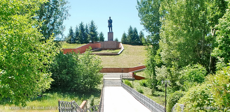
The Memorial Museum of Chokan Valikhanov
"Altynemel" The State Memorial Museum "Altynemel" was opened on September 20, 1985 to the 150th anniversary of the birth of the first Kazakh scientist Shokan Ualikhanov. The number of fund materials is 742 exhibits.
There is an exposition in the museum building that characterizes the era in which Shokan Ualikhanov lived and worked, his personal belongings, correspondence, accounting documents and researches of the scientist.
Shokan (his real name is Muhammadhanafiya) Shyngiz-uly Ualikhanov was born in November 1835 in the fortification of Kusmuryn of the present Kostanay region, he died in April 1865 near the village of Altynemel in the current Almaty region. Shokan Ualikhanov is a great Kazakh scientist, orientalist, historian, ethnographer, geographer, folklorist, enlightener, and democrat.
In the memorial museum of Sh. Valikhanov "Altynemel" with great love tells about the life of Shokan. Here is an exposition devoted to the stages of life and scientific researches of the scientist. Out of five exhibition sections, visitors will learn the known and unknown facts from the biography of Shokan; get acquainted with the things that belonged to him, his sister, letters and diaries, portrait and landscape sketches of the scientist. The first section of the museum exposition presents documents and items characterizing the political, social and cultural environment of the 19th century, the time of the formation of the Kazakh scientist Shokan Valikhanov. The second section introduces Shokan's youth, years of study at the Omsk Cadet Corps, the beginning of military service and the acquaintance of young Shokan with representatives of the Russian intelligentsia.
Then the visitors are presented with reports, diaries, letters, proceedings that make up the research of the scientist Valikhanov on the history, ethnography and geography of Central Asia, Southern Siberia and Kazakhstan.
His correspondence with Russian scientists and writers, diaries, accounting, descriptive and other official documents was analyzed and systematized carefully. The final exposition hall tells how the memory of Shokan Valikhanov, who left a huge scientific heritage for his nation, is honored. These are works of fiction and novels, scientific research, plays, performances and films dedicated to the memory of the scientist.
Shokan's father, Shyngiz Ualikhan-uly, a descendant of Genghis Khan, from childhood attracted his son to collecting materials concerning legends and folk legends, and involved him in the circle of highly educated Russian scientists, engineers, officers. The years of the most intense spiritual formation of Shokan's personality are connected with studying at the Omsk Cadet Corps. Here there was a circle of contacts - an orientalist Kostyletsky N.F., historian Gonsevsky P.V., a publicist, a researcher of the history of the peoples of Siberia and Kazakhstan Yadrintsev N.M., an outstanding geographer Potanin G.N., Annensky N.F. and others.
Subsequently, such figures as Petrashevets S. V., Durov P. P., Semenov-Tien-Shansky, E. P. Kovalevsky, F. M. Dostoevsky entered this circle. The last one recognized in the young officer an extraordinary charismatic personality and experienced extraordinary warm feelings towards him.
Already in the cadet corps, he had a passion for travel and a dream to open the world to the unknown Asia. The dream came true, but in a deeper sense than the young Shokan suggested: he not only explored and described the unexplored places of European science as a geographer, traveler, he opened the veil over the very center of Asia – a man, his history, way of thinking and feeling. Whether the case of his famous Kashgar expedition, thanks to which he became famous for the whole world as a brave traveler, Issyk-Kul expedition or a trip to Kuldzh, does not simply appear as a geographer, economist, ethnographer or royal agent, but through all this and beyond this, before us stands a man standing at the junction of civilizations, deeply worried about the fate of his native people.
The information is taken from the site http://almatyregion-tour.kz/en/location/altynemel-state-memorial-museum-of-shokan-ualikhanov.html
A small video sketch of the park about a trip to the Altyn-Emel Park.


.JPG)


.JPG)